For Strategic Planning, Workforce Assessment, Technical Assistance, Fire Station Location Analysis and More
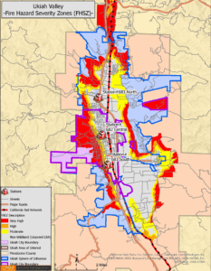
Ukiah Valley, CA Fire Hazard Severity Map (FHSZ) Map
CPSM offers strategic planning for Fire & EMS Services. We offer Standards of Cover, Technical Assistance, Station Location Analysis and more. Our experienced SME’s offer top level advisment, with decades of experience and cutting edge analysis, we can help you with your toughest challenges.
The Center for Public Safety Management (CPSM) is a private consulting and training firm specializing in public safety. The organization is the exclusive provider of public safety technical assistance for the International City/County Management Association ( ICMA).
CPSM provides services to local governments in the critical areas of:
- Police
- Fire
- Emergency Medical Services (EMS)
- Wildfire Risk Assessments & Community Wildfire Protection Plans
- Emergency Management
- Homeland Security
- Dispatch
- Building Accreditation and Codes
CPSM’s mission for Fire and EMS services is to assist local governments in making data-driven decisions to effectively, efficiently, and safely deploy their fire and emergency medical resources.
This mission is achieved by:
-
Providing expert analysis: CPSM utilizes a standardized, fact-based approach to conduct comprehensive evaluations of fire and EMS agencies. This involves forensically analyzing call for service data, workloads, and operational practices.
-
Optimizing resource deployment: They help communities determine appropriate staffing levels, identify optimal fire station locations, and develop service delivery models that align with community risk, population growth, and national standards (like NFPA 1710).
-
Enhancing operational effectiveness: CPSM aims to improve overall performance, response times, and the ability of departments to assemble effective response forces for various emergencies.
-
Promoting best practices and standards: Their work is grounded in industry best practices and national standards, ensuring that recommendations lead to high-quality, safe, and efficient public safety services.
-
Offering strategic guidance: They assist with strategic planning, helping departments develop long-term plans to meet current and future service demands.
-
Supporting leadership development: CPSM also provides services like Fire Chief selection, aiming to identify and develop strong leadership in public safety.
-
Training and education: They conduct workshops and training sessions to equip municipal managers and public safety professionals with the knowledge and skills needed for effective public safety management.
In essence, CPSM strives to empower local governments with the information and strategies needed to provide the highest level of fire and EMS services possible, balancing community needs with fiscal responsibility.
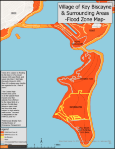
Key Biscayne Flood Map
CPSM leverages the power of GIS for mapping and analysis as an integral and sophisticated component of its data-driven forensic analysis for Fire and EMS services. CPSM’s approach emphasizes Geographic Information Systems (GIS) technology to visualize, analyze, and optimize public safety operations.
Here’s a breakdown of how CPSM harnesses the power of GIS for mapping and analysis in its context:
Forensic Data Visualization:
- CPSM extracts vast amounts of raw data, primarily from a public safety agency’s Computer-Aided Dispatch (CAD) system. This includes every call for service, unit movements, response times, and incident locations. This data is then meticulously cleaned, quantified, and displayed on maps. This goes beyond simple pin-mapping; it’s about revealing patterns and trends that are invisible in raw spreadsheets, enabling powerful insights into service demands through visual analysis.
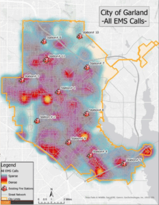
Garland, TX EMS Call Heatmap
Workload and Deployment Optimization:
- Call Density Mapping: CPSM creates maps that show the density of calls for service across a community, highlighting high-demand areas. This is a powerful application of GIS for allocating resources where they are most critically needed.
- Response Time Analysis: GIS is used to analyze actual response times for dispatched units, visualizing how well departments are meeting national standards (e.g., NFPA 1710) and identifying areas with delayed responses that require intervention.
- Unit and Station Workload: Maps can illustrate the workload distribution among different units and stations, showcasing overutilized or underutilized resources for rebalancing through GIS analysis.
- Analysis of Busiest Hours: CPSM can map and analyze call distribution and unit activity across different times of day, revealing peak demand periods and areas for staffing and deployment adjustments powered by GIS.
Optimal Station Location and Resource Allocation:
- “What If” Scenarios: CPSM uses GIS to model various scenarios, such as the impact of relocating existing stations, adding new stations, or adjusting deployment strategies. This allows CPSM to “march out” optimal locations for future fire station sites based on current and projected call volumes and community growth patterns, demonstrating the power of GIS for predictive analysis.
- Coverage Analysis: CPSM can map the coverage areas of existing stations and identify gaps in service delivery, particularly in relation to community risk profiles and emerging development—a key application of GIS for identifying service vulnerabilities.
Community Risk Assessment (CRA) Integration:
- CPSM integrates mapping with CRAs to understand the specific hazards and risks within a community. This allows CPSM to spatially analyze where high-risk areas (e.g., industrial zones, high-density residential areas, areas prone to natural disasters) overlap with service demands and response capabilities. This informs where resources should be placed and how they should be equipped, leveraging GIS for comprehensive risk visualization.
Standard of Cover (SOC) Implementation:
- CPSM’s mapping capabilities, powered by GIS, are crucial for developing and evaluating a department’s “Standard of Cover.” This involves visualizing the department’s ability to assemble an effective response force for various types of incidents (e.g., a structural fire, a multi-vehicle accident) within specific timeframes, considering factors like call type, severity, and the availability of mutual aid. This is a core application of GIS for performance measurement and planning.
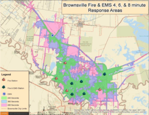
Brownsville, TX Fire & EMS Station Response Areas
Beyond Simple Location:
CPSM’s use of GIS goes beyond just showing where things are. It’s about harnessing the spatial relationships between incidents, resources, and community characteristics to:
- Uncover hidden patterns: Identifying correlations between call types and geographic features to inform operational changes.
- Predict future demands: Using spatial analysis to project where future growth and service needs will occur, aiding long-term planning through GIS’s predictive capabilities.
- Optimize resource deployment: Creating powerful visual tools that allow decision-makers to see the impact of different deployment models.
- Enhance communication: Presenting complex data in an easily understandable visual format for stakeholders and the public, facilitating clearer discussions and decisions.
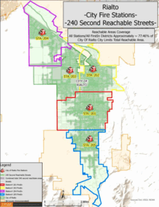
Rialto, CA 240 Second Reachable Streets within FirstIn Zones
In essence, CPSM’s application of the power of GIS for mapping and analysis transforms raw data into actionable insights, providing local governments with a clear visual understanding of their Fire and EMS service delivery and helping them make informed, data-driven decisions for the future. CPSM often leverages commercial GIS software like Esri’s ArcGIS platform for these advanced analyses.
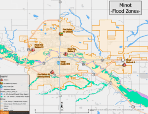
Minot, ND Flood Zones
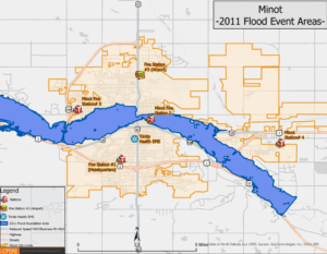
Minot, ND Passed Flood Event Areas
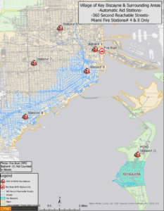
Key Biscayne, FL Mutual Aid 360 Second Reachable Streets
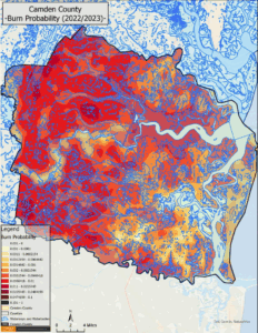
Camden County, GA Burn Probabilty Map
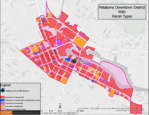
Petaluma, CA Downtown District Map
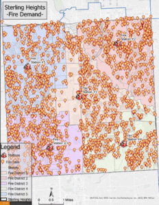
Sterling Heights, MI Fire Demand Map
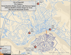
Havorhill, PA 360 Reachable Streets With a Reduced Speed Limit and Partial Bridge Closure Reachable Streets
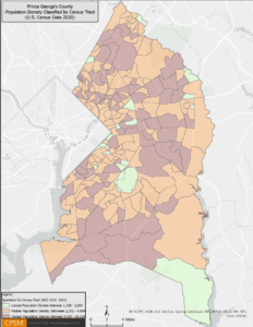
Prince George County, MD Population Distribution Map